Traffic sensors: fusion of radar and visual data to improve signal control efficiency

With the acceleration of urbanization, traffic congestion has become one of the severe challenges faced by many large cities around the world. To address this issue, Intelligent Transportation Systems (ITS) have emerged. Among them, the fusion technology of radar and visual data is gradually demonstrating its enormous potential as a key means to improve the efficiency of traffic signal control. This article aims to explore in detail how this technology can improve traffic flow and safety by optimizing signal control.
The Basic Principles and Applications of Radar Technology
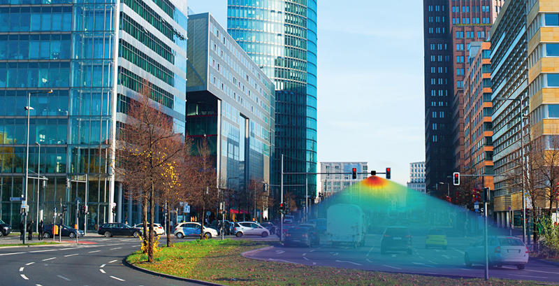
Radar technology, especially millimeter wave radar, plays an important role in traffic monitoring due to its ability to provide accurate target distance and speed information, as well as strong anti-interference ability and all-weather operation. Radar sensors measure the position and speed of vehicles by emitting electromagnetic waves and receiving reflected waves, which is crucial for traffic flow management and signal control. Smartmicro radar were first applied in signal control optimization.
Characteristics and advantages of visual technology
Visual technology mainly includes high-definition cameras installed above or on the roadside, as well as corresponding image processing software. These devices are capable of capturing clear video streams and identifying vehicle types, colors, license plate numbers, and even pedestrians through image processing algorithms. The advantage of visual technology is that it can provide more detailed information than radar, especially useful in identifying specific vehicles or objects.

The advantages of data fusion
1. Improve detection accuracy
By integrating radar and visual data, the detection accuracy of traffic flow and driving behavior can be effectively improved. The speed and distance information provided by radar can be combined with image data from visual sensors to form a more comprehensive analysis of traffic conditions.
2. Enhance environmental adaptability
In low visibility environments, the performance of visual sensors may be affected, while radar sensors can continue to provide accurate data. Data fusion enables traffic signal control systems to operate stably under various environmental conditions.
3. Real time response capability
The fused data can analyze real-time changes in traffic flow, dynamically adjust the duration and switching frequency of signal lights to cope with sudden traffic situations. This adaptive capability significantly enhances the level of intelligence in traffic signal control.
The Current Status of Traffic Signal Control
1. Limitations of traditional signal control
Traditional traffic signal control systems typically rely on timed signals or simple sensing signals. Although these systems can work effectively in certain situations, they often cannot adapt in real-time to changes in traffic flow during peak hours or special circumstances, resulting in traffic delays and safety hazards.
2. The dynamism of traffic flow
Urban traffic flow has a high degree of dynamism and is influenced by various factors such as weather, emergencies, road construction, etc. Traditional control methods are unable to effectively cope with these changes, resulting in delayed switching of traffic lights and affecting the safety of both drivers and pedestrians.
The principle of data fusion and its application in signal control
Data fusion refers to integrating data from different sensors to provide more accurate and comprehensive information than a single sensor. In traffic signal control, the fusion of radar and visual data can achieve optimization in the following aspects:
1. Dynamic signal timing adjustment
Traditional traffic signal control often operates based on a predetermined schedule, and this static method is difficult to adapt to constantly changing traffic conditions. Through the fusion of radar and visual data, the system can monitor the traffic flow in various directions in real time and dynamically adjust the timing of signal lights accordingly. For example, when the radar detects an increase in vehicles on a certain road section, the vision system can further confirm the specific types of these vehicles and adjust the green light time accordingly to reduce congestion on that road section.
2. Adaptive traffic management
In addition to dynamically adjusting signal timing, data fusion can also be used for adaptive traffic management. This means that the signal control system can make real-time decisions based on the current traffic conditions, rather than relying on fixed rules. For example, during peak hours, the system can automatically extend the green light time on main roads, while during non peak hours, it can provide more opportunities for smaller roads, thereby improving the overall efficiency of the road network.
3. Handling of abnormal situations
The fusion of radar and visual data can also help detect and handle abnormal situations. For example, when a traffic accident occurs, radar can quickly locate the accident site, while the visual system can provide specific information about the accident scene. Based on this information, the signal control system can adjust the timing of signal lights in a timely manner, guide subsequent vehicles to detour, and reduce the impact of accidents on traffic.
The fusion technology of radar and visual data has shown great potential in optimizing traffic signal control. Through real-time monitoring and analysis of traffic flow, as well as rapid response to abnormal situations, this technology not only improves the traffic capacity of roads, but also brings new solutions to urban traffic management. With the further development and improvement of related technologies, we can expect a more intelligent, efficient, and safe transportation environment. In the future, with the application of advanced technologies such as artificial intelligence and big data analysis, the functions of intelligent transportation systems will be further enhanced to better serve the sustainable development of cities.
