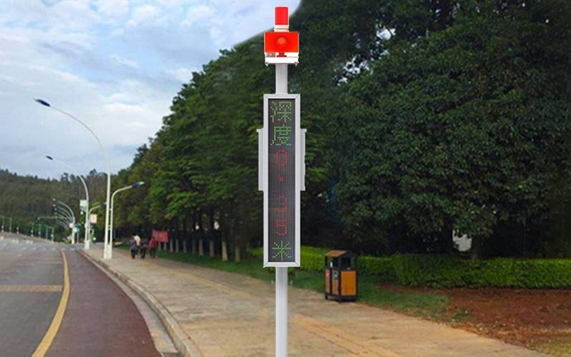
Road Waterlogging Monitoring and Early Warning System

Against the backdrop of global warming, intense rainfall events in summer have become more frequent in recent years, and urban waterlogging has become an increasingly serious problem. In low – lying areas of cities, rainwater tends to accumulate due to poor drainage. River water backflow occurs from time to time, especially when the river flood season coincides with heavy rainfall, and river water can flow back into the city through drainage pipes. In addition, the drainage systems in some cities are poorly planned and outdated, making it difficult to meet the drainage requirements of modern urban development. As a result, low – lying areas, tunnels, overpasses, underground railways, underground garages, and underground shopping malls in cities have become severely affected by waterlogging.
To effectively address urban waterlogging issues and ensure the safe operation of cities and the safety of residents’ lives and property, the Road Waterlogging Monitoring and Early Warning System has been developed. With the Internet of Things (IoT) technology at its core, this system integrates a variety of advanced technologies such as computer networks, databases, communication, and new – type sensors to construct an intelligent monitoring and early – warning system. It enables real – time and accurate monitoring of urban road waterlogging conditions and timely early warnings.
A series of advanced sensing devices with powerful functions and excellent performance are deployed in key waterlogging – prone areas of cities, such as roads, tunnels, and overpasses.
Electronic Water Level Gauge: The electronic water level gauge is one of the core devices for monitoring waterlogging depth. It uses advanced pressure – sensing technology and high – precision sensor elements, and is equipped with an advanced processor chip. This chip has strong computing and data – processing capabilities, enabling not only high – precision measurement but also excellent anti – interference performance. Whether in a complex electromagnetic environment or affected by other external factors, the electronic water level gauge can accurately measure the waterlogging level. Its measurement accuracy can reach the millimeter level, and it can promptly and accurately capture minor changes in waterlogging depth. In some low – lying road sections of cities, the electronic water level gauge can monitor the waterlogging depth in real – time. Once the water level rises, it immediately transmits the data to subsequent systems, buying valuable time for dealing with waterlogging problems.
Rainfall Sensor: The rainfall sensor is an important tool for monitoring rainfall. It uses advanced optical – sensing principles or tipping – bucket structures to accurately count and measure raindrops. This sensor can monitor rainfall in real – time, record the rainfall intensity per unit time and the cumulative rainfall. During rainstorms, the rainfall sensor can quickly and accurately obtain rainfall data and transmit these data to the data center. By analyzing the rainfall data in combination with other monitoring data, it is possible to deeply analyze the causes of waterlogging, determine whether it is due to excessive rainfall in a short period or poor drainage system, etc., providing strong data support for formulating targeted countermeasures.
Camera: As a visual monitoring device, the camera plays an indispensable role in waterlogging monitoring. These cameras have high – definition shooting functions and can directly capture images of the waterlogging site. Whether it is the waterlogging situation on the road or the waterlogging depth and water flow direction in the tunnel, the camera can clearly record them. Moreover, some cameras have night – vision and intelligent analysis functions, enabling them to work normally even at night or in low – light environments. The intelligent analysis function can automatically identify abnormal phenomena such as waterlogging areas and trapped vehicles and transmit relevant information to management decision – makers in a timely manner. By viewing the images captured by the cameras, management decision – makers can promptly understand the actual situation, visually assess the severity and impact range of waterlogging, and thus make more scientific and reasonable decisions.
The data center uses big data analysis technology and intelligent algorithms to deeply mine and analyze the massive data transmitted. The system can calculate key indicators such as waterlogging depth, waterlogging area, and waterlogging growth rate in real – time. By combining historical data and weather forecast information, it can predict the development trend of waterlogging. Through the establishment of mathematical models, the system can accurately determine the waterlogging risk levels of different areas under different rainfall conditions, providing a scientific basis for early – warning issuance.
When the monitored waterlogging data exceeds the preset early – warning threshold, the system immediately activates the early – warning mechanism. Early – warning information is released to relevant departments and the public through multiple channels, such as text messages, WeChat official accounts, electronic displays, radio, and television. After receiving the early – warning information, relevant departments can quickly take emergency measures, such as dispatching drainage facilities, diverting traffic, and organizing rescue operations. The public can also plan their travel routes reasonably based on the early – warning information, avoid going to dangerous waterlogging areas, and ensure their own safety.
